


Lake Victoria's Peatland Conundrum

This story is produced by The Xylom and copublished by Sayansi Magazine, a Kenya-based science magazine published by the Media for Environment, Science, Health and Agriculture (MESHA).
Nduru is a village that once was. Today, silence greets anyone who visits what remains of it.

In western Kenya, the highlands gradually flatten into the vast expanse of Lake Victoria, the world’s second-largest freshwater lake. Along its shores lies Kisumu, one of Kenya’s major cities, surrounded by wetlands that support fishing communities and small farming villages. Nduru was one of them. Today, only a few traces remain to show that a village once stood here.
On either side of an elevated earthen road, slick with recent rains, the fields have become shallow lakes. A line of electricity poles rises above the reeds — silent reminders that they once supplied power to the people of Nduru. Perched atop one of them is a grey crowned crane.
As the elegant bird spreads its wings and disappears over the waterlogged fields, Bernard Aringi Odenyi, a 49-year-old director of a community school, arrives on his motorcycle. A former resident of Nduru, he points toward a cluster of ruins. “You see those walls? That used to be my house.”
Odenyi pulls out his phone and shows a photograph of himself standing inside the house, floodwater up to his knees. Today, only a few crumbling walls remain.
Every rainy season, Lake Victoria swells, a problem worsened by the loss and encroachment of the surrounding wetlands. Fishing and farming communities along its shores bear the brunt as their homes and livelihoods are repeatedly disrupted.

The Lake That Keeps Rising
After severe flooding during the 2024 rainy season, Nduru became uninhabitable, forcing almost all its residents, including Odenyi, to relocate to nearby villages.
It was the third time Odenyi had been displaced by floods. The latest disaster meant more than losing his home, as he had to move back in with his parents.
“In our tradition, once you are married, you never go back to live with your parents. Only a grandchild may return to the grandparents’ compound and stay there,” he says. “Worst of all is that the floods have forced people to lose their traditions and ancestral lands. I think nature is reclaiming its lost glory.”
Odenyi now lives in Nyang’ande, where the community school he heads is struggling to cope with an influx of displaced children. Built for 500 pupils, it now serves nearly twice that number.
Scientists attribute much of Lake Victoria’s rising water levels to climate change and heavier rainfall across its vast catchment, much of which lies in the Kenyan Highlands. Water from inland rivers drains into the lake, raising levels along its shores.
The Lake Victoria Basin Commission, headquartered in Kisumu, advises the governments of Kenya, Uganda, Tanzania, and Rwanda on managing the basin’s shared waters. Paul Kariuki, the commission’s regional ecosystems monitoring specialist, says the rising water level is not a new phenomenon. “In some seasons, the lake level has risen by more than half a metre,” he says. “That’s enough to submerge ports, roads, and entire communities along the shoreline.”
Swallowing the Land
Like Nduru, many of the farming and fishing villages around Kisumu have been affected by flooding. One of them is Sango Rota, where the Sondu River empties into Lake Victoria after flowing from the highlands of Kericho County. During heavy rains, the river regularly breaches its banks. In recent years, however, residents have faced a double threat: flooding from upstream and backflow from the lake itself.
Despite the challenges, Sango Rota’s Chief Seth Oluoch Agwanda, who oversees the government’s flood mitigation efforts, remains optimistic as he leads the way along a network of dikes and stone-filled gabions built to hold back the lake. During the floods of April and May, he said that about 1,500 residents of Sango Rota were forced to seek shelter in displacement camps. “But two weeks ago, we were able to close the last displacement camp,” he says proudly, stepping around pools of water to keep his leather boots dry. “People have been able to return to their homes.”

Near the shoreline, Agwanda greets a group of fishermen sheltering beneath a tarp stretched between wooden poles. But when they begin sharing their views on the government’s flood prevention efforts, including the construction of dikes, he quietly slips away.
Kennedy Otieno, a 49-year-old fisherman, says, “Every time during elections, politicians come here and promise us [to construct] cemented dikes. But after the elections nothing happens.” The other fishermen nod. “All are false promises. And we have to witness how the lake takes everything from us.”
In Nyang’ande, there is little sign of rain. Under a clear blue sky, sunlight glints off corrugated iron roofs and white tarps covering narrow walkways. “These days it’s not just the rains we worry about,” displaced fisherman Joseph Ogola says. “The lake has risen so much that even on a sunny day, a strong wind can push the water over into our land.”


Back at the Lake Victoria Basin Commission office, Paul Kariuki says encroachment on wetlands and peatlands is worsening the floods, as factories and housing developments are being built in areas that should be protected.
Environmental activist Michael Otieno Nyanguti, who founded the Magnam Environmental Network, has taken several cases to court in an effort to stop development on reclaimed wetlands.
“People get authorisation from the government to build on wetlands, and often there is corruption behind it,” says Nyanguti over the phone.
Some of Kenya’s wetlands are peatlands — carbon-rich ecosystems that play a crucial role in regulating the global climate.
Wetlands That Matter
Peatlands cover only about 3% of the Earth’s land surface, yet they store nearly twice as much carbon as all the world’s forests combined. Their destruction not only releases vast amounts of stored carbon but also removes one of nature’s most effective buffers against flooding.
Francis Odhiambo Omungo of Ecofinder Kenya, co-organiser of the International Workshop of the Venice Agreement for Peatlands, held in Kisumu in June, says peatlands are invaluable for climate protection, biodiversity conservation and flood control. “Apart from being the world’s most efficient carbon storage, they act like a sponge and absorb and retain huge amounts of water.”
Close to Kisumu, extensive wetlands line the shores of Lake Victoria. Some are believed to be peatlands but remain unmapped, making conservation more difficult.

Yet identifying peatlands is not always straightforward. During the workshop, Colombian ecologist David Santiago Rocha Cardenas pointed to bubbles rising through the water. “Look at the gases coming up; and the smell, these are typical characteristics of peatlands,” he said.
Katharina Renate, a German hydrologic researcher from the University of Hamburg, disagreed. “I’m not convinced,” she said. “For peat to form, the ground needs to be waterlogged for long periods of time to be able to store carbon. There is too much inflow and outflow here.”
While the scientists debated, 70-year-old Margaret Akinyi relied on local knowledge shaped over generations. Returning from harvesting papyrus, she explained that the Luo language has long distinguished between two kinds of wetlands.
“Thidnia is the swamp where the water is moving,” she says. “Anete is where the water stays. It is soft and keeps wobbling; you can even walk over it.”
She has never heard the term “peatland,” but her description suggests that anete refers to one.


Livelihood or Conservation?
For decades, Akinyi has depended on these wetlands for her livelihood, harvesting papyrus that is woven into mats and baskets.
“When they dry up, some people burn what remains of the wetlands so they can farm there; the land is very fertile,” she says. She has watched parts of the wetland give way to agriculture and real estate, despite the protection they provide to surrounding communities.
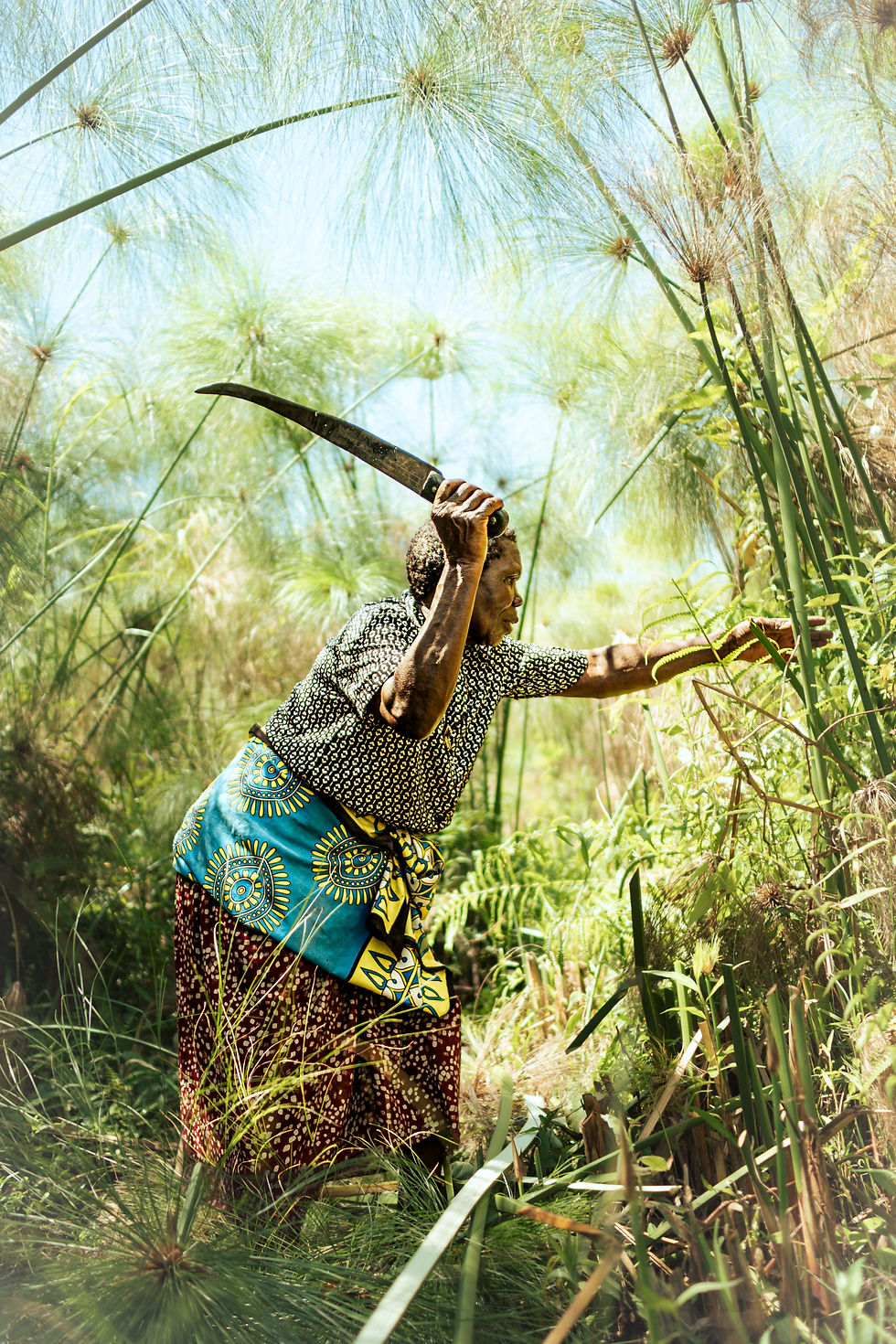
During floods, fishermen clear papyrus to reach fishing grounds. When the water recedes, farmers remove the vegetation to cultivate the fertile soil.
Intended as a temporary refuge, the displacement camp in Nyang’ande has become a permanent home for some residents displaced from Nduru. One of them is 37-year-old Judith Awino Litunge, who describes herself as a hustler because life has forced her to be one.
“We understand that wetlands can protect us from flooding,” she says. “But as displaced farmers, we often have no choice but to destroy them for farming or fishing in order to survive.”
Litunge pauses before adding, “The government gives us rations from time to time, but they won’t allocate us new land. We have nowhere to go. There is nothing more shameful than being a farmer without a piece of land to work on.”
Samuel Oron, Kisumu County’s Director of Special Programmes and Disaster Management, disputes residents’ claims that they have not been offered alternative land. He says some families decline — or even sell — plots allocated on higher ground and choose to remain near the wetlands.
“These people prefer to stay close to the wetlands,” Oron says. “They benefit from fishing during the floods and farming in the fertile grounds when the wetlands dry up or even when they have destroyed them.”
An Approaching El Niño
As villagers criticise the government’s flood response, Oron says the county is doing what it can.
“At the county level, we do everything we can to protect our communities from floods by desilting riverbeds and building dikes and stone-filled gabions.”
He acknowledges that wetland encroachment is a growing problem but says final approval for developments rests with Kenya’s National Environment Management Authority (NEMA). The county, he says, has mapped flood-prone areas and wetlands to guide planning, dike construction and disaster preparedness, while promoting farming practices that protect rather than degrade wetlands.
As Lake Victoria continues to rise, the fate of its surrounding communities is increasingly tied to that of its wetlands. While many local communities exploit wetlands out of necessity, activists warn that government-approved developments continue to encroach on them for profit.
Meteorologists warn that an El Niño event expected later this year could push Lake Victoria even higher. Scientists say wetlands remain one of the region’s best natural defences against flooding. But for families who depend on them to survive, conservation without alternatives is no solution at all.


